Main product
NORA
Onboard optical-inertial navigation module for UAVs that provides GNSS-like coordinates without satellite signal.
- MAVLink 2 over UART
- ArduPilot 4.5.5+
- Loiter, RTL, SmartRTL and AUTO support
VISUAL NAVIGATION SYSTEMS
DroneOps develops optical-inertial navigation modules that help UAVs operate when GPS is unavailable, jammed or spoofed.
Company
DroneOps is a science and technology startup working at the intersection of industrial systems and defense technology.
Navigation Beyond GPS
DroneOps develops optical-inertial and satellite-assisted navigation for loitering, safe return and autonomous UAV missions in environments where GPS is unavailable, jammed or spoofed.
Main product
Onboard optical-inertial navigation module for UAVs that provides GNSS-like coordinates without satellite signal.
R&D direction
Satellite relocalization support that helps correct accumulated drift by comparing drone imagery with satellite imagery.
Main product
NORA (Navigation Optical Resilient Architecture) connects to a flight controller through MAVLink 2 and acts as a GPS replacement or backup when satellite positioning is unavailable. It uses a nadir-facing camera and IMU to estimate position and orientation in real time, then outputs GNSS-compatible data into ArduPilot without changing mission planning or adding a pilot UI.
Performance depends on visibility and surface texture. Heavy rain, snow, dense fog, large homogeneous water surfaces and uniform snow cover can reduce navigation quality.
Dimensions
65 x 50 x 30 mm
Interface
MAVLink 2 / UART
Power
8-45 V / 15 W
Operating height
50–500 m *
* Can operate at higher altitudes — customisation required for specific customer needs.
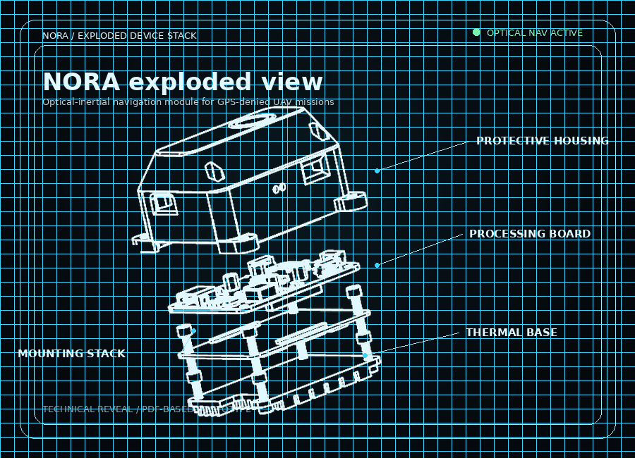
Hardware
Exploded view of the module structure: protective housing, processing board, mounting stack and thermal base.
Module
Optical-inertial navigation
Size
65 x 50 x 30 mm
Interface
MAVLink 2 / UART
Power
8-45 V / 15 W
Field validation
On 12 May 2026, DroneOps demonstrated NORA at the Brave1 defense innovation cluster, running fixed-wing and multirotor missions in a representative GNSS-denied scenario.
0.75%
Fixed-wing drift error
Over 90 km demonstration mission
1.8%
Multirotor drift error
Over 25 km demonstration mission
Brave1 is the Ukrainian government defense innovation cluster supporting next-generation defense technology.
Main product
Onboard optical-inertial navigation module for UAVs that provides GNSS-like coordinates without satellite signal.
01
Position holding without GPS. Designed for UAV teams that need stable operation in EW-contested environments or controlled holding over an area.
02
Return scenarios for platforms operating at short and medium ranges. When GPS is unavailable or jammed, the UAV can return using NORA navigation data without continuous manual control.
03
Route-based autonomous missions for UAVs of different types in GPS-denied conditions.
Integration process
The integration path is built for UAV manufacturers, system integrators and defense customers that need a practical route from platform requirements to flight evidence.
01
Define platform requirements: use case, range, altitude, operational limits, integration plan and joint test plan.
02
Physical and software integration of the module, power and UART connection, autopilot configuration.
03
Calculate the transformation matrix between the navigation module coordinate system and the UAV coordinate system.
04
Validate NORA operation through a controlled flight profile.
05
Analyze logs, refine limitations, update mission configuration and prepare the next task with a clear evidence trail.
Deployment options
DroneOps can support different procurement, integration and deployment models depending on platform maturity and operational context.
Standalone hardware kit — a deployable navigation and mission package for teams that need an integrated field configuration.
Engineering support for platform-specific wiring, autopilot settings, calibration and joint flight testing.
Licensed navigation software for approved UAV programs and technical partners with their own integration path.
Program-level deployment support for manufacturers, integrators, defense primes and multi-team environments.
A field-ready hardware package for teams that need navigation capability without rebuilding their full workflow.
Ecosystem
DroneOps integrates with leading autonomy software vendors, UAV manufacturers and defense innovation programs.
Partner
Brave1
Defense innovation cluster · Ukraine
Cluster participant
DroneOps is a participant of Brave1, the Ukrainian government defense innovation cluster supporting next-generation defense technology.
Active integrations
Swarmer
Swarm autonomy software
Airlogix
UAV logistics platform
Partner · Argus
Fixed-wing producer · undisclosed
Partner · Nightbird
Multirotor producer · undisclosed
NORA is integrated with leading UAV manufacturers and autonomy software providers. Below are publicly disclosed partners.
Operator workflow
NORA is designed to fit into familiar autopilot and integrator practices rather than adding another operational interface.
The connection model is familiar to teams already working with ArduPilot, MAVLink 2 and flight controllers.
Navigation state is delivered through standard autopilot indicators. Operators do not need an additional interface.
The navigation module is built with several protection layers and avoids exposing navigation data unnecessarily.
FAQ
Short answers to the questions integrators and operators ask most. For anything not covered here, request an integration call.
NORA (Navigation Optical Resilient Architecture) is DroneOps' optical-inertial visual navigation system for UAVs. It replaces or backs up GNSS using a nadir camera and IMU, outputs MAVLink 2 GNSS-compatible data to ArduPilot, and supports Loiter, RTL, SmartRTL and AUTO modes.
At the Brave1 defense innovation cluster demonstration on 12 May 2026, NORA achieved 0.75% drift error over a 90 km fixed-wing mission and 1.8% drift error over a 25 km multirotor mission.
NORA connects to flight controllers running ArduPilot 4.5.5+ via MAVLink 2 over UART. No additional pilot interface is required — navigation state is delivered through standard autopilot indicators.
NORA operates between 50 and 500 metres AGL, with higher altitudes available through per-customer customisation. Performance depends on surface visibility and texture — heavy rain, snow, dense fog, large homogeneous water surfaces and uniform snow cover can reduce navigation quality.
DroneOps is headquartered in London. R&D, flight team and production are based in Ukraine. R&D and flight team are also based in Poland.
Contact
Share your platform requirements and our team will help define the integration path, test profile and deployment model.
Prefer direct contact?
contact@droneoperations.ai

